

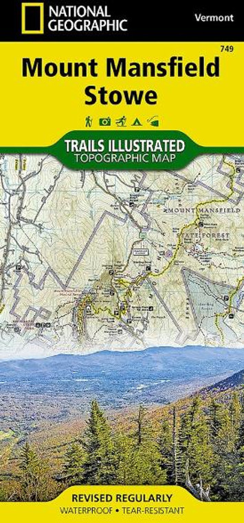
Mount Mansfield/Stowe #749
National Geographic
$14.95
(No reviews yet)

Write a Review
National Geographic
Mount Mansfield/Stowe #749
- Created in cooperation with the Vermont Agency of Natural Resources, this map delivers unparalleled detail from Sandbar State Park and Malletts Bay to the city of Barre
- Covers local and town parks, lakes, reservoirs and other waterways, state parks, forests and wildlife management areas
- Includes the Green Mountains, Camels Hump State Park, Mount Mansfield State Forest, Burlington, Essex Junction, Montpelier, Barre and Stowe as well as a complete road network
- Easy-to-read, yet highly detailed map shows comprehensive trail and road networks, along with designated trails for hiking, horseback riding, biking and more
- Clearly marked navigational aids with UTM coordinate grids, scale bar and full legend, essential for safely navigating the backcountry with GPS or compass
- Features key points of interest such as scenic views, campgrounds, trailheads, boat launches and picnic sites
- Color-coded boundaries for public lands including national parks, national forests, national monuments, ranger districts, wilderness areas, state parks and wildlife refuges
- 1:63,360 scale
- Printed in the USA on durable, lightweight, waterproof and tear-resistant material designed to withstand all weather conditions
- Folded dimensions: 4.25 x 9.25 in.; unfolded dimensions: 25.5 x 37.75 in.
Related Products
-
-
-
-
Sale


